 Katsurayama
Mountain Katsurayama
Mountain
桂山
Ushibumi Archaeological Site Tour
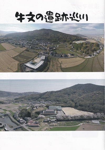
牛文の遺跡巡り
Friends and Neighbors,
友人、そして近隣の皆様へ
Welcome to the Katsurayama Mountain and Ushibumi
Archaeological Site Tour page. The information on this page
was obtained from a map and tour pamphlet created by one of
our neighbors (Iriesan) which highlights some of the
archaeological points of interest found around mostly the
base of the mountain.
桂山と牛踏遺跡ツアーのページへようこそ。このページの情報は、近隣住民の方(入江さん)が作成された地図とツアーパンフレットに基づいています。このパンフレットには、主に山の麓周辺にあるいくつかの遺跡が紹介されています。
Katsurayama Mountain is located directly behind our house,
and can be seen from our family room. The mountain is
located in the northwest corner of Setouchi City, and rises
to an elevation of 245 meters (804 feet), making it one of
the top 10 highest mountains in the city. The hiking trails
became overgrown due to years of neglect but now a group of
local residents, including our oldest son Shai, have been
engaged in a trail restoration project to make the hiking
trails usable again and to highlight some interesting
features found along the way.
桂山は我が家のすぐ裏手にあり、リビングからも眺めることができます。瀬戸内市の北西部に位置し、標高は245メートル(804フィート)で、市内でも10本の指に入る高山です。長年の放置により登山道は草木が生い茂っていましたが、長男のシャイをはじめとする地元住民グループが、登山道を再び利用できるようにし、道沿いの見どころを紹介する整備事業に取り組んでいます。
This page is an ongoing project. Please check often for
updates.
このページは現在作成中のプロジェクトです。最新情報については、定期的にご確認ください。
Please note: the information on this
page was translated from Japanese to English using ChatGPT.
My wife will be reviewing the translation for accuracy soon.
ご注意:このページの情報は、ChatGPTを使用して日本語から英語に翻訳されたものです。
妻がまもなく翻訳の正確さを確認する予定です。 |
|
|
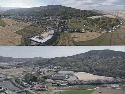
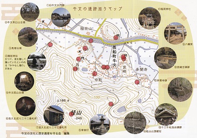 Ushibumi
Archaeological Site Tour Map Ushibumi
Archaeological Site Tour Map
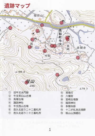
牛文の遺跡巡りマップ
Click for full size image
クリックするとフルサイズ画像が表示されます
This map shows the 14 points of interest located on and
around Katsurayama Mountain.
この地図は、桂山とその周辺にある14か所の見どころを示しています。 |
- 1. 旧 牛 文 水 門 跡 - Former Ushibumi
Water Gate Site
- 2. 牛 文 茶 臼 山 古 墳 - Ushibumi
Chausuyama Ancient Burial Mound
- 3. 馬 塚 古 墳 - Mazuka Ancient Burial
Mound
- 4. 諏 訪 神 社かつて、夜を徹して
踊っていたといわれる「かやなし踊り」がある - Suwa Shrine In the past, through
the night it is said that they danced the “Kayanashi
Dance” there is.
- 5. 牛 文 西 山 古 墳 - Ushibumi Nishiyama
Ancient Burial Mound
- 6. 邑 久 北 巡 り 二 十 二 番 札 所 - Oku Kita
Pilgrimage No. 22 Sacred Site
- 7. 邑 久 北 巡 り 二 十 三 番 札 所 - Oku Kita
Pilgrimage No. 23 Sacred Site
- 8. 常 夜 灯 - Stone Lantern
- 9. 八 幡 宮 - Hachiman Shrine
- 10. 宮 崎 古 墳 群 - Miyazaki Burial
Mound Group
- 11. 稲 荷 神 社 - Inari Shrine
- 12. 多 聞 寺 跡 - Site of Tamon-ji
Temple
- 13. 十 二 ケ 池 古 墳 群 - Jūnikeike Burial
Mound Group - one kanji character
could not be copied
- 14. 桂 山 山 頂 礎 石 - Foundation Stone
at the Summit of Mount Katsura
|
Association for Preserving Ushibumi’s Cultural and
Historical Heritage - Editor
牛文の文化と歴史遺産を守る会 - 編集 |
|
|
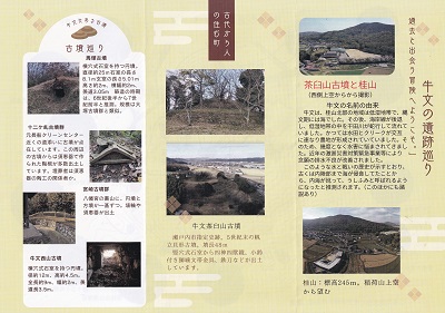 Ushibumi
Ruins Tour Ushibumi
Ruins Tour
牛文の遺跡巡り
Click for full size image
クリックするとフルサイズ画像が表示されます
Welcome to an adventure where you encounter the past.
過去と出会う冒険へようこそ。 |
Top Right Column Picture
右列上の写真
Chausuyama Burial Mound and Mount
Katsura
茶臼山古墳と桂山
(Photographed from above on the west side)
(西側上空からから撮影)
Origin of the name Ushibumi
牛文の名前の由来
Ushibumi, in the northern area of Mount Katsura, was a
low-lying wetland, and during the Jōmon period it was sea.
After that, the coastline retreated, and the Hida River
meandered through the low-lying wetland. In the past, rice
paddies and creeks alternated, forming farmland. As a
result, the area suffered from flood damage many times. In
recent years, emergency severe-disaster countermeasure
projects and similar efforts have finally improved the
long-standing drainage problems. As this history of battling water shows, possibly people connected with Sue ware pottery craftsmen. Miyazaki Burial Mound Group. Behind Hachiman Shrine are round burial mounds, and
it is presumed that, because the sea once extended far
inland, the word uchiumi (“inland sea”) gradually changed in
pronunciation and came to be called
ushifumi. (There are also other
theories.)
牛文は、桂山北部の地域は低湿地帯で、縄文 期 に は 海 で し た 。そ の 後 、 海 岸 線 が 後 退
十ニケ古墳群 し、低湿地帯の中を干田川が蛇行して流れて 元長船クリーンセンター い ま し た 。か つ て は 水 田
と ク リ ー ク が 交 互 近くの道添いに古墳が点 に 連 な り 農 地 が 形 成 さ れ て い て い ま
し た 。そ 在しています。この周辺 のため、幾度となく水害に悩まされてきまし の古墳からは須恵器で作 た 。近 年 の
激 甚 災 害 対 策 緊 急 事 業 等 に よ り られた陶棺が多数出土し
念願の排水不良が改善されました。このような水と戦いの歴史が示すとおり、 器の陶工の関係者か。
古くは内陸部まで海が侵食してたことから、内海が訛って、うしふみと呼ばれるよう 宮崎古墳群
になったと推測されます。(このほかにも諸 八幡宮の裏山に、円墳と 説あり)
Bottom Right Column Picture
右列下の写真
Mount Katsura: elevation 245 m. Viewed from above
Inariyama.Road length: 3.5 m.
桂山:標高245m。稲荷山上空 道長3.5m。 から望む
Top Center Column Picture
中央列上の写真
A town inhabited since ancient times
古代から人の住む町
Bottom Center Column Picture
中央列下の写真
Ushibumi Chausuyama Burial Mound
牛文茶臼山古墳
Designated historic site of Setouchi City. A scallop-shaped
burial mound from the late 5th century. Mound length: 48 m.
From the vertical stone chamber, a Four Deities / Four
Beasts mirror, a lion-bite patterned belt fitting with small
bells, an iron sword, and other items have been excavated.
Ushibumi Nishiyama Burial Mound. A round burial mound with a
horizontal stone chamber.
瀬戸内市指定史跡。5世紀末の帆 立貝形古墳。墳長48m 竪穴式石室から四神四獣鏡、小鈴 牛文西山古墳
付き獅噛文帯金具、鉄刀などが出土 横穴式石室を持つ円墳。 しています。
Top Left Column Picture
左列上の写真
Top half curved text could not be
copied.
Burial Mound Tour
古墳巡り
Mazuka Burial Mound
馬塚古墳
A round burial mound with a horizontal stone chamber.
Diameter: approx. 25 m
Stone chamber length: 8.1 m
Burial chamber length: 5.01 m
Height: approx. 2 m
Width: approx. 2 m
Passageway: 3.05 m
The construction period is estimated to be from the latter
half of the 6th century to the first half of the 7th
century. Its scale is similar to the Ōtsuka burial mound
group.
横穴式石室を持つ円頃。 直径約25m石室の長さ 8.1m玄室の長さ5.01m 高さ約2m、横幅約2m、 羡道3.05m
築造の時期 は、6世紀後半から7世 (西側上空からから撮影) 紀前半と推測。規模は大 牛文の名前の由来 塚古墳群と類似。
Second Left Column Picture
左列2番目の写真
Jūnike Burial Mound Group
十ニケ古墳群
Former Osafune Clean Center. Burial mounds are scattered
along the roadside nearby. From the burial mounds in this
area, many ceramic coffins made of Sue ware have been
excavated. The people buried there may have been connected
to Sue ware pottery craftsmen. As the Hida River once flowed
through this area, rice paddies and creeks alternated to
form farmland. As a result, the area suffered repeatedly
from flood damage. In recent years, emergency
severe-disaster countermeasure projects and similar efforts
have finally improved the long-standing drainage problems.
As this history of battling water shows.
元長船クリーンセンター いました。かつては水田とクリークが交互 近くの道添いに古墳が点
に連なり農地が形成されていていました。そ 在しています。この周辺 のため、幾度となく水害に悩まされてきまし
の古墳からは須恵器で作 た。近年の激甚災害対策緊急事業等により られた陶棺が多数出土し 念願の排水不良が改善されました。
ています。埋葬者は須恵 このような水と戦いの歴史が示すとおり、 器の陶工の関係者か。
Third Left Column Picture
左列3番目の写真
Miyazaki Burial Mound Group
宮崎古墳群
On the hill behind Hachiman Shrine, there is one round
burial mound and one square burial mound. Haniwa clay
figures and Sue ware have been excavated.
八幡宮の裏山に、円墳と 説あり) 方墳が一基ずつ。埴輪や 須恵器が出土
Bottom Left Column Picture
左列下の写真
Ushibumi Nishiyama Burial Mound
牛文西山古墳
A round burial mound with a horizontal stone chamber.
Diameter: approx. 12 m
Height: approx. 4.5 m
Total length: approx. 9 m
Width: approx. 2 m
Passageway length: 3.5 m
横穴式石室を持つ円墳。 しています。 径約12m、高約4.5m。 全長約9m、幅約2m、羨
桂山:標高245m。稲荷山上空 道長3.5m。 |
|
|
|
|
 The
line of text in the picture could not be copied and
translated. The
line of text in the picture could not be copied and
translated.
Click for full size image
クリックするとフルサイズ画像が表示されます
|
|
|
 Ruins
Map Ruins
Map
遺跡マップ
Click for full size image
クリックするとフルサイズ画像が表示されます
This map shows the 14 points of interest located on and
around Katsurayama Mountain.
この地図は、桂山とその周辺にある14か所の見どころを示しています。
Please note: the second number 13 on
the points of interest list below the map is supposed to be
number 14.
ご注意ください:地図の下にある観光スポット一覧の2番目の番号13は、正しくは番号14です。 |
- 1. 旧 牛 文 水 門 跡 - Former Ushibumi
Water Gate Site
- 2. 牛 文 茶 臼 山 古 墳 - Ushibumi
Chausuyama Ancient Burial Mound
- 3. 馬 塚 古 墳 - Mazuka Ancient Burial
Mound
- 4. 諏 訪 神 社かつて、夜を徹して
踊っていたといわれる「かやなし踊り」がある - Suwa Shrine In the past, through
the night it is said that they danced the “Kayanashi
Dance” there is.
- 5. 牛 文 西 山 古 墳 - Ushibumi Nishiyama
Ancient Burial Mound
- 6. 邑 久 北 巡 り 二 十 二 番 札 所 - Oku Kita
Pilgrimage No. 22 Sacred Site
- 7. 邑 久 北 巡 り 二 十 三 番 札 所 - Oku Kita
Pilgrimage No. 23 Sacred Site
- 8. 常 夜 灯 - Stone Lantern
- 9. 八 幡 宮 - Hachiman Shrine
- 10. 宮 崎 古 墳 群 - Miyazaki Burial
Mound Group
- 11. 稲 荷 神 社 - Inari Shrine
- 12. 多 聞 寺 跡 - Site of Tamon-ji
Temple
- 13. 十 二 ケ 池 古 墳 群 - Jūnikeike Burial
Mound Group - one kanji character
could not be copied
- 14. 桂 山 山 頂 礎 石 - Foundation Stone
at the Summit of Mount Katsura
|
|
|
 Origin
of the name Ushibumi Origin
of the name Ushibumi
牛文(うしふみ)の名前の由来
Click for full size image
クリックするとフルサイズ画像が表示されます
The northern area of Mount Katsura was a low-lying wetland,
and during the Jōmon period it was sea. Later, as the
coastline retreated, the Hida River meandered through the
wetland. In the past, rice paddies and creeks alternated,
forming farmland. As a result, the area suffered repeatedly
from flood damage. In recent years, long-awaited drainage
problems were improved through emergency severe-disaster
countermeasure projects and similar efforts. As this history
of battling water shows, it is presumed that because the sea
once extended far inland, the word uchiumi (“inland sea”)
gradually changed in pronunciation (uchiumi > uchyumi >
ushuumi) and came to be called Ushifumi. (There are also
other theories.)
桂山北部の地域は低湿地帯で、縄文期には海でした。その後、海岸
線が後退し、低湿地帯の中を干田川が蛇行して流れていました。かつ
ては水田とクリークが交互に連なり農地が形成されていていました。
そのため、幾度となく水害に悩まされてきました。近年の激甚災害対
策緊急事業等により念願の排水不良が改善されました。このような水
と戦いの歴史が示すとおり、古くは内陸部まで海が侵食してたことか
ら、内海が訛って、(うちうみ>うちゅみ>うしゅうみ)うしふみと呼
ばれるようになったと推測されます。(このほかにも諸説あり)
History of the Hida River (Ushibumi
Water Gate)
干田川(牛文水門)の歴史
Excavation began in Genroku 3 (1690), and the Hida River,
which had previously been winding, was widened. The former
Ushibumi Water Gate was built in Bunsei 5 (1822). Later, in
Heisei 7 (1995), the new Ushibumi Water Gate was installed.
When the former Ushibumi Water Gate was removed, the stone
materials that had been used were placed behind the
gymnasium of Kō School, where a commemorative plaque has
been installed.
元禄3年1690年に開削がはじまり、それまで曲がりくね っていた干田側は川幅も広がり旧牛文水門が文政5年
1822年に設けられた。その後、平成7年1995年に新牛文 水門が設置された。旧牛文水門の撤去にあたり、使われ
ていた石材は、国府小学校の体育館裏に設置され、銘板 が置れている。
Top of Aerial View Picture
航空写真の上部
The blue dotted line shows the course of the Hida River
before the Edo period, when it meandered greatly. The
colored line shows the present course.
青い点線は、江戸時代以前の干田川の流れ 大きく蛇行 食色は現在の流れ
Bottom of Aerial View Picture
航空写真の下部
Aerial photograph of the Ushibumi area in 1947 (Shōwa 22),
courtesy of the Geospatial Information Authority of Japan.
牛文地域 1947年(昭和22年)の航空写真 国土地理院所蔵
|
|
|
 Ushibumi
Chausuyama Burial Mound Ushibumi
Chausuyama Burial Mound
牛文茶臼山古墳
Click for full size image
クリックするとフルサイズ画像が表示されます
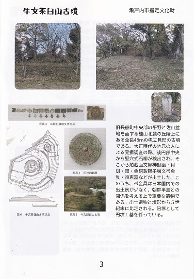
Top Pictures
上の写真
Designated Cultural Property of Setouchi City
瀬戸内市指定文化財
Picture 3
写真3
Photo 3: Lion-Bite Patterned Belt Fitting with Small Bells
写真3 小鈴付獅噛文帯金具
Note: the text in the gray area could
not be copied.
Picture 4
写真4
Photo 4: Four Deities / Four Beasts Mirror
写真4 四神四獣鏡
Picture 5
写真5
Photo 5: Ushibumi Chausuyama Burial Mound
写真5 牛文茶臼山古墳
Figure 6
図6
Figure 6: Burial Mound of the Ushibumi Chausuyama Burial
Mound
図6 牛文茶臼山古墳墳丘
This is a scallop-shaped burial mound with a total length of
48 meters, located on a hill at the northern foot of Mount
Katsura, which marks the boundary between the central plain
of the former Osafune Town and the Sayama Basin. During an
excavation conducted by local residents in the Taishō
period, a vertical stone chamber was discovered in the
center of the rear circular portion. From it were excavated
an imported decorated-band divine-beast mirror, shell
bracelets, stirrups, a gilt-bronze lion-bite patterned belt
fitting, Sue ware, and other items. Among these, the belt
fitting is a particularly important artifact for considering
connections with the Korean Peninsula, as examples excavated
in Japan are rare. Based on the excavated artifacts and the
shape of the mound, it is dated to the end of the 5th
century. It is accompanied by one round burial mound as an
attendant mound.
旧長船町中央部の平野と佐山盆 地を画する桂山北麓の丘陵上に ある全長48mの帆立貝形の古墳 である。大正時代の地元の人に
よる発掘調査の際、後円部中央 から竪穴式石槨が検出され、そ こから舶載画文帯神獣鏡·貝 釧·鐙·金銅製獅子噛文帯金
具·須恵器などが出土した。こ のうち、帯金具は日本国内での 出土例が少なく、朝鮮半島との 関係を考える上で重要な遺物で
ある。出土遺物と墳形から5世 紀末に比定される。陪塚として 円墳1基を伴っている。 |
|
|
|
 Burial
Mounds Burial
Mounds
古墳
Click for full size image
クリックするとフルサイズ画像が表示されます
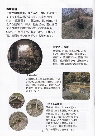
Mazuka Burial Mound
馬塚古墳
Located on the south side of the western slope of the hill.
A round burial mound with a diameter of 25 meters. It has a
one-sided corridor-type horizontal stone chamber opening to
the north. The total length of the stone chamber is about
8.1 meters; the burial chamber is 5 meters long, 2 meters
wide, and 1.95 meters high. At the edge of a nearby hill
there is another round burial mound, about 12 meters in
diameter. It has a one-sided corridor-type horizontal stone
chamber opening to the west. The existing length of the
stone chamber is 5.6 meters; the burial chamber is 4 meters
long and about 1.8 meters wide. The ceiling consists of four
stones. There is also the Kirigirisu Burial Mound, which has
a stone shelf.
丘陵西斜面南側。径25mの円墳。北に開口 する片袖式の横穴式石室。石室全長約
8.1m、玄室長5m、幅2m、高1.95m。付 近の丘陵端に。円墳。径約12m。西に開口
する片袖式の横穴式石室。石室現存長 5.6m、玄室長4m、幅約1.8m。天井石4 石。石棚を持つきりぎりす古墳がある。
Ushibumi Nishiyama Burial Mound
牛文西山古墳
Located at the edge of a hill. A round burial mound
approximately 12 meters in diameter and about 4.5 meters
high. It has a horizontal stone chamber with a total length
of about 9 meters, a width of about 2 meters, and a
passageway length of 3.5 meters. The construction period is
estimated to be from the latter half of the 6th century to
the first half of the 7th century. Its scale is similar to
that of the Mazuka Burial Mound Group.
丘陵端。円墳。径約12m、高約 4.5m。横穴式石室。全長約9m、 幅約2m、羨道長3.5m。築造の時
期は、6世紀後半から7世紀前半と 推測。規模は馬塚古墳群と類似。
Miyazaki Burial Mound Group
宮崎古墳群
Located on the top of the hill behind Hachiman Shrine. There
is one square burial mound measuring about 20 meters on each
side and about 2 meters high, and one round burial mound on
the hilltop measuring about 20 meters in diameter and about
1.5 meters high. Haniwa clay figures and Sue ware have been
excavated.
八幡宮の裏にある丘陵頂部。一辺 約20m、高約2mの方墳と。丘陵頂 部。円墳。径約20m、高約1.5mの
円墳が一基ずつ。埴輪や須恵器が 出土している。
Jūnikeru Burial Mound Group
十ニケル古墳群
A group of burial mounds located at the edge of a hill near
the former Osafune Clean Center. Nine round burial mounds
have been identified. They measure about 12 meters in
diameter and about 4.5 meters in height. Some of the mounds
have horizontal stone chambers. Many ceramic coffins made of
Sue ware have been excavated from this burial mound group.
It is presumed that those buried there were connected to Sue
ware pottery craftsmen.
元長船クリーンセンター近くの 丘陵端にある古墳群。9つの円墳 が確認されている。径約12m、
高約4.5m。横穴式石室を持つ古 墳もある。この古墳群からは須 恵器で作られた陶棺が多数出土
しています。埋葬者は須恵器の 陶工の関係者と推察される。
|
|
|
 Tamonji
Settlement Tamonji
Settlement
多聞寺集落
Click for full size image
クリックするとフルサイズ画像が表示されます
Text Above Map
地図の上の文字
Place names related to the Tamonji settlement
多聞寺集落の開係地名
Text Below Map
地図の下の文字
(Source: “Place Names and People’s Livelihoods” by Hiroshi
Urakami)
(出典:「地名と人々の営み」浦上宏氏)
Site of Fukuroku
袋玖跡
At the upper reaches of Jūniketani Pond, traces of a furnace
were found, and slag was confirmed in the surrounding area.
Slag is what is commonly called kanakuso—the waste produced
during metal smelting.
The discovery was made by former Osafune Town Superintendent
of Education Takashi Yamazaki (now deceased), who devoted
great effort to the protection of buried cultural properties
in Osafune Town.
Place names related to the Tamonji settlement
(Source: “Place Names and People’s Livelihoods” by Hiroshi
Urakami)
十ニヶ谷池の上流部に炉の跡がありその周辺で鉱滓が 確認されました。 鉱滓は金属を精錬する際にできるいわゆる金屎(かな
くそ)です。 発見したのは長船町の埋蔵文化財保護に尽力された山51 崎孝志元教育長(故人)です。 多聞寺集落の開係地名
(出典:「地名と人々の営み」浦上宏氏)
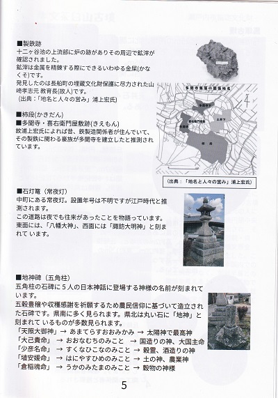
Kakidan
柿 段 ( か き だ ん )
Site of Tamonji Temple / Kiemon
Residence
多 聞 寺 · 喜 右 衛 門 屋 敷 跡 ( き え も ん )
According to the late Hiroshi Urakami, people involved in
iron production once lived here, and it is presumed that a
powerful clan connected to that iron production established
Tamonji Temple.
故浦上宏氏によれば昔、鉄製造関係者が住んでいて、 その製鉄に関わる豪族が多聞寺を建立したと推測され ています。
Stone Lantern (Jōyatō / all-night
lantern)
石 灯 篭 ( 常 夜 灯 )
An all-night stone lantern located in Nakamachi. The year it
was erected is unknown, but it is presumed to date to the
Edo period.
This road evidently had traffic even at night.
The east face is inscribed with “Hachiman Daijin,” and the
west face with “Suwa Daimyōjin.”
中町にある常夜灯。設置年号は不明ですが江戸時代と推 測されます。 この道路は夜でも往来があったことを物語っています。
東面には、「八幡大神」、西面には「諏訪大明神」と刻ま れています。
Earth Deity Monument (Pentagonal
Pillar)
地 神 碑 ( 五 角 柱 )
The names of five deities from Japanese mythology are carved
into the pentagonal stone monument. This is a stone monument
erected based on farmers’ folk beliefs to pray for abundant
harvests and to give thanks for the crops. Many are found in
southern Okayama Prefecture. In the northern part of the
prefecture, many are seen as round stones inscribed with
“Earth Deity.”
“Amaterasu Ōmikami” → the sun goddess and supreme deity
“Ōnamuchi no Mikoto” → a god of nation-building; another
name for Ōkuninushi no Mikoto
“Sukunahikona no Mikoto” → a grain spirit and god of sake
brewing
“Haniyasuhime no Mikoto” → a goddess of earth and
agriculture
“Ukanomitama no Mikoto” → a deity of grain
五角柱の石碑に5人の日本神話に登場する神様の名前が刻まれて
います。五穀豊穣や収穫感謝を祈願するため農民信仰に基づいて造立され
た石碑です。県南に多く見られます。県北は丸い石に「地神」と 刻まれているものが多数見られます。
「天照大御神」→あまてらすおおみかみ→太陽神で最高神 「大己貴命」 →おおなむちのみこと →国造りの神、大国主命
「少彦名命」 →すくなひこなのみこと→穀霊、酒造りの神 「埴安媛命」 →はにやすひめのみこと→土の神、農業神
「倉稲魂命」 →うかのみたまのみこと→穀物の神様
|
|
|
 Mount
Katsura Mount
Katsura
桂 山
Click for full size image
クリックするとフルサイズ画像が表示されます
Text Under First Picture
最初の写真の下の文字
Principal image of Sacred Site No. 22
22番札所の本尊
Text Under Second Picture
2番目の写真の下の文字
Nakamachi Daishi Hall
中町大師堂
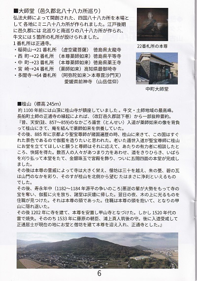
Daishi Hall (Oku District North
88-Temple Pilgrimage)
大 師 堂 ( 邑 久 郡 北 八 十 八 カ 所 巡 り )
Modeled after the original Shikoku 88-Temple Pilgrimage
founded by Kōbō Daishi, smaller local 88-temple pilgrimages
were established in various regions. In the late Edo period,
northern and southern 88-site pilgrimages were created in
Oku District, and five sacred sites were established in
Ushibumi. Sacred Site No. 1 is Shōtsūji Temple.
弘法大師によって開創された、四国八十八カ所を本場と して各地にミニ八十八カ所が作られました。江戸後期
に邑久郡には北巡りと南巡りの八十八カ所が作られ、 牛文には5箇所の札所が設けられました。 1番札所は正通寺。
Inariyama → Sacred Site No. 21
(Principal image: Kokūzō Bosatsu)
Corresponds to Tairyūji Temple, Tokushima Prefecture
Nishimachi → Sacred Site No. 22
(Principal image: Yakushi Nyorai)
Tokushima Prefecture, Byōdōji Temple
Nakamachi → Sacred Site No. 23
(Principal image: Yakushi Nyorai)
Corresponds to Yakuōji Temple, Tokushima Prefecture
Miyazaki → Sacred Site No. 24
(Principal image: Yakushi Nyorai)
Corresponds to Hotsumisakiji Temple, Kōchi Prefecture
Tamonji → Sacred Site No. 64
(Amida Nyorai → Principal image: Bishamonten)
Corresponds to Maegamiji Temple, Ehime Prefecture (mountain
worship)
1番札所は正通寺。 ·稲荷山→21 番札所 (虚空蔵菩薩) 徳島県太龍寺 22番札所の本尊 ·西町→22番札所
(本尊薬師如来)徳島県平等寺 ·中町→23番札所 (本尊薬師如来)徳島県薬王寺 ·宮崎→24 番札所
(薬師如来)高知県最御埼寺 ·多聞寺→64番札所 (阿弥陀如来>本尊毘沙門天) 愛媛県前神寺(山岳信仰)
Mount Katsura (Elevation: 245 m)
桂 山 ( 標 高 245m)
About 1,100 years ago, Katsurayama Temple stood on the
summit. It is the highest peak in the Ushibumi and Haji
areas.
According to the origin record of Shōtsūji Temple in Haji,
Osafune Town (partially excerpted and summarized from the
revised lower volume of the Oku District Gazette):
“In the middle of the Ten’an era (note: 857–859), a
renunciant monk came to Mount Katsura carrying a statue of
Yakushi Nyorai on his back, built a hermitage, and
worshipped Yakushi Nyorai there.”
約1100年前には山頂に桂山寺が鎮座していました。牛文·土師地域の最高峰。
長船町土師の正通寺の縁起によれば、(改訂邑久郡誌下巻)から一部抜粋要約。
『昔、天安(註、857~859)のなかごろ遁世(とんせい)入道が薬師如来の像を背負
って桂山にきて、庵を結んで薬師如来を供養していた。
After that, in 885, when the revered monk Shōbō was
traveling throughout the provinces from Kyoto, he came to
Mount Katsura and thought that, because this land had such
beautiful scenery, he wanted to build a temple complex
there. When the elderly renunciant monk asked Shōbō to build
a hall on Mount Katsura, Shōbō agreed and consulted the
influential local people, who gladly gave their consent.
Several hundred people gathered and worked together,
clearing a road, cutting away the thickets, constructing the
main hall, decorating the temple buildings with gold,
silver, jewels, and precious stones, and at last completing
a main hall measuring five bays on all four sides.
その後、885年に京都より聖宝尊師が諸国遍歴の時、桂山に来きて、この国はすぐ
れた景色であるので伽藍を造りたいと思われた。老いた遁世入道が聖宝尊師に桂山
にお堂を立ててほしいと願うと尊師はそれに応えて、あたりの有力者に相談したと
ころ、快諾を得た。数百人の人々があつまり力をあわせ、道をきりひらき、いばら
を刈り払って本堂をたて、金銀珠玉で宮殿を飾り、ついに五間四面の本堂が完成し ました。
After that, through the spiritual power of its principal
image, the temple greatly prospered. The monks’ quarters
numbered more than thirty, and the vermilion roofs and
blue-green tiles adorned the temple precincts. Viewed from
the north side of Mount Katsura, its appearance was truly
that of a pure and sacred temple.
その後は本尊の霊威によって寺は大きく栄え、僧坊は三十を越え、朱の甍、碧の瓦
は山門のなかを彩り、そのすが桂山を北側から望むたはまさに浄刹といえるもの でした。
Later, during the Juei era (1182–1184, around the time of
the Genpei War), a large band of evildoers seized the
temple’s treasures and set fire to the temple complex,
reducing the halls to ashes. On the following night, the
head priest noticed something shining in a tree. It was the
head of the principal image. The priest embraced the head of
the principal image and fled to nearby Mount Kabuto to hide.
その後、寿永年中(1182~1184年源平の争いのころ)悪逆の輩が大勢をもって寺の
宝を奪い、伽藍に火を放ち、諸堂は灰燼に帰した。翌日の夜、木の上に光るものを
住職が見つけた。それは本尊の頭であった。住職は本尊の頭を抱いて、となりの甲 山に隠れ退いた。
Later, in 1202, a temple was built and the principal image
was enshrined there, and it was named Kōzanji Temple.
However, it was destroyed by lightning in the 1520s. After
that, in 1533, Fujiwara no Ason Uragami no Mahito, Governor
of Chikugo—who later took Buddhist vows and became known as
Shōtsū Koji—built a hall and monks’ quarters at the present
location, welcomed the principal image there, and
established Shōtsūji Temple.”
その後1202年に寺を建て、本尊を安置し甲山寺となづけた。しかし1520年代の
雷で焼失。そののち1533年に藤原の朝臣、浦上真人筑後の守。後に入道受戒して
正通居士が現在の地にお堂と僧坊を建て本尊を迎え入れ、正通寺とした。』 |
|
|
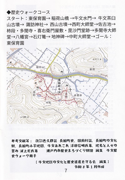 Historical
Walking Course Historical
Walking Course
歴 史 ウ ォ ー ク コ ー ス
Click for full size image
クリックするとフルサイズ画像が表示されます
Start: Higashi Nursery School → Inariyama Bridge → Ushibumi
Water Gate → Ushibumi Chausuyama Burial Mound → Suwa Shrine
→ Nishiyama Burial Mound → Nishimachi Daishi Hall → Sakoi
Pond → Kakidan / Tamonji / Kiemon Residence Site /
Bishamondō Site → Tamonji Daishi Hall → Hachiman Shrine →
Stone Lantern → Earth Deity Monument → Nakamachi Daishi Hall
→ Goal: Higashi Nursery School
スタート:東保育園→稲荷山橋→牛文水門→牛文茶臼 山古墳→諏訪神社→西山古墳→西町大師堂→佐古池→
柿段·多聞寺·喜右衛門屋敷·毘沙門堂跡→多聞寺大師 堂→八幡宮→石灯篭→地神碑→中町大師堂→ゴール: 東保育園
References: Revised Oku District Gazette, History of Osafune
Town, History of Kō Village, Cultural Properties of Osafune
Town, Osafune Town Koaza (Small Place-Name) Map, Various
Notes on Ushibumi by Nobuaki Ukita, Place Names and People’s
Livelihoods by Hiroshi Urakami
Edited by the Setouchi City Historical Town Development
Foundation
From the “Ushibumi Historical Walk” booklet
参考文献等:改訂邑久郡誌 長船町史、国府村誌、長船町の文化 財、長船町小字地図、牛文あれこれ 浮田信明氏著、地名と人々の
営み 浦上宏氏著 瀬戸内市歴史まちづくり財団 編集 牛文歴 史ウォーク冊子
Edited by the Association for Preserving the Culture and
Historical Heritage of the Ushibumi District
Created in January, Reiwa 8 (2026)
【牛文地区の文化と歴史遺産を守る会 編集】 令和8年1月作成
|
|
|
|
|
|
|